Mallorca - The Queen of the Balearic Islands
-

Palma: Modernization of Plaza Mayor planned - focus on retail
The historic Plaza Mayor in the heart of Palma de Mallorca is to be comprehensively modernized. The goal is to strengthen retail and make the city center more attractive. The…
-

Palma: No more fines for campers with motorhomes!
Originally, fines were planned for overnight stays in motorhomes. These penalties will now not be enforced for the time being. This decision could have far-reaching consequences…
-

Mallorca's salt-free bread: Traditional baking from the Middle Ages
Mallorca's salt-free bread delights with its authentic flavor. The specialty of this baked good lies in the traditional production method, passed down for generations. It is a…
-

Large demonstration in Palma calls for solutions to the housing crisis
They called on politicians to take action to guarantee the right to housing for the locals. The event showes growing social tensions.
-

Tradition meets innovation: Mallorcan cuisine reinterpreted
Mallorcan cuisine is experiencing a renaissance: local restaurateurs combine tradition with innovation to revitalize traditional cuisine.
-

Home design as a reflection of Mallorca
Mallorcan interior design – from Mediterranean to modern. No one can resist Mallorca's charm. The scent of cedar, the warm, bright light and elegance of Marés sandstone.
Articles about the island of Mallorca:

Palma de Mallorca
The region around the capital, Palma (Google Maps), borders the Migjorn landscape zone to the west. The island's government seat is also its supply center.

The Southwest
The southwest of the island of Mallorca boasts diverse landscapes. The region is characterized by chic harbors and a vibrant nightlife.

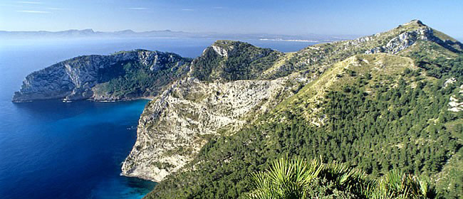
The Northwest
The Serra de Tramuntana is well-connected to hiking and cycling trails, making it an ideal destination for independent travelers and nature lovers.
The North
The north forms the transition from the mountains to the "Pla" plain. Although the region is crisscrossed by rivers and waterways, little arable land remains.

The Northeast
The northeastern Llevant is famous for its beaches and coves, some of which are overrun by mass tourism. Examples include Cala Rajada and Cala Millor.

The Southeast
The southeast extends along the coastline and borders Llevant to the northeast and Pla de Mallorca and Palma to the northwest.

The South
The flat interior of the south of Mallorca flows into wide sandy beaches or rises until it abruptly ends at high cliffs.

The center of the island
Pla de Mallorca, the center of Mallorca, is bordered to the northwest by the Serra de Tramuntana mountain range and to the east by the Serres de Llevant.