
The Palma region: capital and supply center of the Balearic Islands
The region around the capital, Palma (Google Maps) borders the Migjorn landscape zone to the west. The island's government seat is also its supply center. Most of the infrastructure facilities, including the largest airport and the largest port, are located here. The city is also the island's center for tourism. Located along the Mediterranean coast on the Bay of Palma, the city and its metropolitan area are approximately 30 kilometers long. Approximately 500,000 people live here – more than 50% of the island's population. To the northwest, the area is bordered by the Serra de Tramuntana, and to the northeast, smaller hill ranges form the border. The sandy beach of Playa de Palma stretches for about 10 kilometers to the southeast, all the way to El Arenal, and to the west, Cala Major.

Economically, the city and its surrounding area rely primarily on the service sector, especially tourism. Trade, administration, and transport also play an important role. The establishment of industrial companies in the Palma region has even been prohibited since the 1970s. The University of the Balearic Islands, founded in 1978—a comparatively small university with 13,700 students—has its headquarters here.
The central area of Palma is the Old Town, which is still bordered today by the ring roads that follow the line of the city fortifications, which were only demolished in 1902. A ring of densely built-up areas up to two kilometers wide separates the old town from its suburbs and commercial areas.
Climate of the Palma region
The small southern island of Cabrera belongs to the Palma area. Like the rest of the island, Palma also has a Mediterranean climate with mild winters and hot summers, although temperatures in midsummer are nowhere near as high as in the island's interior, with highs usually hovering around 33°C. In winter, the lowest temperatures are usually around 8°C in January and February, but they can also climb to 15°C during these months. The rainiest months are October and November, although Palma is not a particularly rainy region anyway.
Foundation and history of the rule of Palma
The city of Palmaria Palmensis (Palm of Victory), founded in 123 BC by the Roman consul Quintus Caecilius Metellus Balearius, remained the most important city in the Balearic province for a long time. In the 4th century, like many other Roman cities, it fell into decline, but this decline was halted by the Arabs at the beginning of the 10th century. By the time they were expelled by the Aragonese at the beginning of the 13th century, the Arabs had established an Arab-Islamic culture here. With a brief interruption as the Kingdom of Mallorca, the area remained under Aragonese rule until the island became Spanish. The city's eventful history—and the Talayotic culture, which dominated for thousands of years until the arrival of the Romans—can still be seen today in many corners of the city and its surroundings.

Sightseeing features
Many historical sights bear witness to the many cultures and peoples that have settled here throughout history. The old town of Palma is a sight in itself. The mix of Spanish, Catalan, and Arabic elements gives it a very special charm. Numerous small alleys and staircases lead visitors to the countless impressive buildings located here. One of the landmarks of the old town of Palma de Mallorca is the Gothic Cathedral of Santa Maria, known locally as "La Seu" and also known as the "Cathedral of Palma." Construction of the bishopric began in the 13th century under King Jaume I. It was not consecrated until the end of the 16th century, and the main façade was not added until the mid-19th and early 20th centuries. Due to the long construction period of the various parts of the cathedral, various architectural styles throughout history can be observed here: Gothic, Late Gothic, Renaissance, Mannerism, some Baroque elements, Classicism, and Catalan Art Nouveau – a true delight for amateur art historians and interested laypeople alike.
In addition to this gem, the old town is home to 31 other churches, most of which are also Gothic. Directly next to the cathedral is the impressive Royal Palace of La Almudaina. The old town also features another of the city's landmarks: the Llotja dels Mercaders / Llotja de Palma. This masterpiece of Gothic architecture served as the seat of the Maritime Trade Authority since the 15th century and is now used for changing art exhibitions. Further southwest, the medieval Castell de Bellver rises above the old town. Built at the beginning of the 14th century, it was converted into a museum in the 1930s.

City tours: Get to know Palma de Mallorca
The Old Town and Around the Center
Getting to Know Palma: City Tour 1
- The starting point is the Park in front of the Almudaina.
- The tour leads from the former Royal Palace to the Cathedral of La Seu, then via the Estudio General to Calle Portella and the Museo de Mallorca.
- Then to the Church of San Francisco with a detour to Calle Serra with the Arab Baths, continuing to the Church of Santa Eulalia on the square of the same name and past the Town Hall into the pedestrian zone of Calle Colon and Plaza Mayor.
- On the north side of Plaza Major, go down the stairs and up the Rambla (Via Roma) to the Church of Santa Magdalena, and then continue on to the Church of the Holy Spirit of the large Hospital General.
- Return along Calle San Jaime and across Plaza Weyler, then back up the stairs to Plaza Mayor.
- From there, take a detour north along Calle San Miguel to Plaza Olivar with its market of the same name (mornings only), which is Palma's most beautiful market (the fish market is very impressive).
- Continue to Plaza de Espana, on whose northeast side is the terminus of the "Red Lightning," the old railway to Soller.
- Continue to the Church of Santa Margarita.
- Across the wide pedestrian zone Oms, head back down to the Rambla and along the "flower avenue" Paseo del Borne back to the starting point.
- From there, walk along the Paseo Maritimo to the old stock exchange, La Lonja, and the Consolado del Mar.
Behind this lies the Apuntadores pub street. Done - time for a cold beer!

City Tour 2: La Lonja, Santa Catalina, Castell de Bellver, and Parc de Mar
- The starting point is the Paseo Maritimo at the intersection with Avenida Maura.
- From there, go to Plaza de la Reina and across Plaza del Rey Juan Carlos to Calle Sant Jaume.
- At the church of the same name, turn left into Gaverrera and then left again across Agua to return to the upscale shopping street Avenida Rey Jaime III.
- From here, continue to Paseo Mallorca, then left to Plaza Porta de Santa Catalina with a detour to the Es Jonquet district with its three windmill ruins high above the harbor, and via Olivera/San Pedro back to Paseo Maritimo.
- Continue west via Plaza Puente to Calle Andrea Doria and then right, following the sign to Pueblo Español.
- From there, via San Armadans to Parc Bellver with Bellver Castle.
- Afterwards, you can continue the tour by car or bus to the western suburbs of Terreno, San Agustin, Illetas, Portals Nous, and Costa Bendinat as you wish.
- Walking paths along the seafront promenade (Paseo Maritimo) from the harbor to the Parc del Mar directly below the cathedral.

Basic data:
| Administration | |
|---|---|
| Country: | Spain |
| Autonomous Community: | Balearic Islands |
| Island: | Mallorca |
| County: | Palma |
| Altitude: | 15 m above sea level |
| Area: | 208.63 km² |
| Population: | 550,000 |
| Population Density: | 1,994 inhabitants/km² |
| Postal Code(s): | 07000–07099 |
| Municipality Number (INE): | 07040 Template:Infobox Municipality in Spain/Maintenance/cod_ine |
| Nearest airport: | Palma Airport (8 km from the city center) |
| Official language: | Catalan, Spanish Template:Infobox municipality in Spain/Maintenance/Own language |
| Address of the municipal administration: | Plaça de Cort, 1 07001 Palma |
| Website: | www.palma.cat |

An administrative part of Palma: The island of Cabrera
The rocky island of Cabrera also belongs administratively to Palma, but is located much further south off the coast of the Migjorn region. Ferries to the island are offered regularly and take about 30 minutes. The flat and rocky island, with rather sparse vegetation, is now a national park. In addition to its beautiful natural surroundings, it also boasts several attractions, including an ethnographic museum where visitors can learn about the small island's eventful history, a tranquil lighthouse, several caves, and the remains of a fortress tower built in the 14th century as protection against pirates.
Articles about the island of Mallorca:

The Southwest
The southwest of the island of Mallorca boasts diverse landscapes. The region is characterized by chic harbors and a vibrant nightlife.

The Northwest
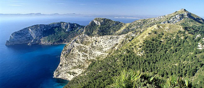
The Serra de Tramuntana is well-connected to hiking and cycling trails, making it an ideal destination for independent travelers and nature lovers.
The North
The north forms the transition from the mountains to the "Pla" plain. Although the region is crisscrossed by rivers and waterways, little arable land remains.

The Northeast
The northeastern Llevant is famous for its beaches and coves, some of which are overrun by mass tourism. Examples include Cala Rajada and Cala Millor.

The Southeast
The southeast extends along the coastline and borders Llevant to the northeast and Pla de Mallorca and Palma to the northwest.

The South
The flat interior of the south of Mallorca flows into wide sandy beaches or rises until it abruptly ends at high cliffs.

The center of the island
Pla de Mallorca, the center of Mallorca, is bordered to the northwest by the Serra de Tramuntana mountain range and to the east by the Serres de Llevant.