
The Northeast of Mallorca: Llevant
Llevant translates as "east," and that's precisely where this landscape zone is located: in the east of the island. The municipalities of Capdepera, Manacor, Son Servera, Sant Llorenç des Cardassar, and Artà are located here.
In 2013, approximately 78,714 people lived here, covering an area of 579.31 square kilometers. The settlement history of the Llevant can be traced back to the end of the 2nd millennium BC. Of particular historical significance is the settlement of Ses Païsses, a Bronze Age archaeological site of the Talayotic culture, which predominated in the western Mediterranean, including the Balearic Islands, between the 13th and 2nd centuries BC. It is characterized by its buildings, especially towers, constructed using the megalithic (cyclopean) masonry technique. Ses Païsses is located southeast of Artà. The exact age of the settlement has not yet been determined, but finds indicate habitation from approximately 1000 to 100 BC. At least as important and therefore not to be overlooked is the settlement of Capocorb Vell, which dates to approximately the same period. It lies south of Llucmajor and is one of the best-researched Talayotic settlements in the Balearic Islands.
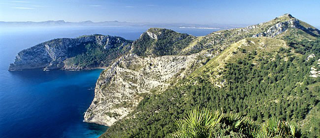
The landscape of the Llevant is characterized by numerous mountains and hills, as well as sandy beaches, cliffs, and agricultural land. The flora of the (mostly bare) rolling hills is very diverse and Mediterranean, with shrub formations of broom and mastic alternating with tree heather, wild olive trees, pines, and firs. Lavender and rosemary are also common. Garigue can be seen in every valley, while dwarf palms and yew grass predominate in the higher reaches.
The northeast of the Llevant is famous for its beaches and bays, some of which are overrun by mass tourism. Examples include Cala Rajada and Cala Millor. The west of the landscape zone is predominantly used for agriculture. The Llevant region has a Mediterranean climate, which means short and mild but very humid winters and hot, dry summers. As early as January, the first almond blossoms bloom in the valleys, followed by the remaining fruit trees in March, until the dry period begins in May. During this time, temperatures can reach up to 40°C, which usually results in the withering of vegetation. September ushers in autumn with a humid climate, and it becomes pleasant and cooler in October, when it begins to rain occasionally and the land turns green again. In winter, it rarely drops below 10°C, although it can sometimes snow. The inhabitants of the Llevant region know their winds very well and have even named several mountains and valleys after them. Nine winds are particularly important for the region, most notably the easterly wind Llevant, which is quite warm in summer but can also reach hurricane force in winter.
Numerous culinary specialties originate from the Llevant landscape zone. One example is ensaïmades, a typical snail-shaped pastry that may only be made from regional products from certified producers. Most of these producers are located in the Llevant region. The same applies to the producers of sobrasada, a sausage specialty made from dried minced pork. Samphire, an essential part of Mallorcan cuisine, also grows abundantly on the coast of the Llevant region. The Llevant is also considered a very good wine-growing region, and one of the island's largest liqueur producers, the Moya company in Artà, is located here. The region is not exactly known for its large-scale industry, but there are significant gravel pits, pearl production, and two concrete block factories. Smaller artisanal businesses, such as traditional basket weavers and furniture manufacturers, are more prominent. Tourism is the Llevant's main source of income, accounting for 75% of the gross domestic product. The construction industry accounts for 8%, and agriculture only 3.5%.

The Llevant Peninsula Natural Park, declared a nature reserve in the fall of 2001, encompasses an area of approximately 21,500 hectares, full of beautiful bays and unspoiled mountains. Many peregrine falcons, booted eagles, and Audouin's gulls call this area home, and the turtle population is also the largest on the entire island.
Other top attractions in the region include the stalactite cave systems of the Coves del Drac ("Dragon Caves") in the east, south of Porto Cristo, and the Archaeological and Ethnographic Museum of Manacor in the 14th-century Torre dels Enagistes. In the eastern town of Artà, there are numerous churches and monasteries to visit, including the late Gothic parish church of Transfiguració del Senyor, the Baroque Franciscan monastery of Sant Antoni de Pàdua, and the pilgrimage church of Sant Salvador, which towers imposingly above the town. Here, too, there is a stalactite cave, numerous beaches, a small museum and library, as well as the remains of Talayotic settlements. In the small town of Capdepera, further caves and the famous Castell de Capdepera, a fortress from the 13th century, await their explorers.
The agricultural center of the Llevant is the municipality of Manacor, where the main attractions, besides the Torre dels Enagistes, are the Dominican monastery of Sant Vicenç Ferrer from the 17th/18th centuries. Century, the neo-Gothic church of Nostra Senyora dels Dolors, and the exhibition halls of two pearl factories. The small town of Son Severa is also home to three churches worth seeing and some beautiful beaches, and Sant Llorenç des Cardassar (San Lorenzo) boasts a Talayotic village and a 17th-century fortified tower.
Articles about the island of Mallorca:

Palma de Mallorca
The region around the capital, Palma (Google Maps), borders the Migjorn landscape zone to the west. The island's government seat is also its supply center.

The Southwest
The southwest of the island of Mallorca boasts diverse landscapes. The region is characterized by chic harbors and a vibrant nightlife.

The Northwest
The Serra de Tramuntana is well-connected to hiking and cycling trails, making it an ideal destination for independent travelers and nature lovers.
The North
The north forms the transition from the mountains to the "Pla" plain. Although the region is crisscrossed by rivers and waterways, little arable land remains.

The Southeast
The southeast extends along the coastline and borders Llevant to the northeast and Pla de Mallorca and Palma to the northwest.

The South
The flat interior of the south of Mallorca flows into wide sandy beaches or rises until it abruptly ends at high cliffs.

The center of the island
Pla de Mallorca, the center of Mallorca, is bordered to the northwest by the Serra de Tramuntana mountain range and to the east by the Serres de Llevant.